SIGHTSEEING
• Nature Areas & Beaches • |
NATURE AREAS & BEACHES
Dinadiawan Beach
Location: Along the Dicadi Highway
Getting There: Take a private vehicle from Baler town proper and use the Dicadi highway to drive north.
Travel Time: Four hours
Dinadiawan Beach is one of the most beautiful beaches in Aurora, with a fabulous view of the Pacific Ocean, the lush, diverse forests of the Sierra Madre Mountain Range, and the rock formation along the shoreline. And, Dinadiawan Beach is resort-free.
Dingalan Bay View Site
Location: Barangay Tanawan, Dingalan
Getting There: From Cabanatuan, Nueva Ecija, take a bus bound for Tanawan
Travel Time: Two hours and 10 minutes
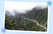
"Tanawan," as the place is called, means "viewsite." Upon approaching the border of Dingalan and Nueva Ecija, one passes through an area sloping upwards. At its peak is Dingalan Bay View Site. Undeveloped, except for a solitary nipa hut and several electric poles, the area provides fantastic view of the town and the blue bay, as well as the green mountains and the igneous rock formations. Dingalan Bay is a total contrast from the hot, dry and brown environment of Nueva Ecija. One would be amazed by the almost sudden emergence of greenery that overlooks Dingalan upon reaching the Bay View Site. Dingalan Bay View Site is a perfect place for photography and picnicking.
Ditumabo Falls
Location: Barangay Ditumabo, San Luis
Getting There: Hire a jeep or take a private vehicle from Baler town proper going to Bgy. Ditumabo passing through Poblacion San Luis. From there, it is a 4-km hike over rough terrain and river trail. It is advisable to hire guides who are knowledgeable of the area.
Travel Time: Two hours and 15 minutes' drive and another 3-hour hike.
The crystal clear water of Ditumabo Falls gushes endlessly, flowing and twisting among countless rocks and boulders. The trek to the falls traverses several kilometers through the river and over a few steep mountain trails surrounding the falls on both banks. Occasionally, the trekker will unavoidably come upon fallen or cut logs that serve as either natural bridges or obstacles. Approximately 140 feet high, the falls are surrounded by huge cliffs-an unforgettable sight for nature lovers!
Hillsite of Proposed Ermita Park
Location: Barangay Zabali, Baler
Getting There: Take a tricycle from Baler town proper to the river outlet south of Sabang Beach. From there, one can walk to the site.
Travel Time: Five minutes by tricycle, approximately 35 minutes' walk to the foot of the hill and 15 minutes' trek uphill.
This shrub-covered area provides an excellent view of the town of Baler, Sabang Beach, Cemento and Dimadimalangat islet. It is a short, steep trek from the foot of the hill, through small trees and cogon grass, to the top. Hidden beneath a clump of trees are the almost unrecognizable remains of a bell tower. Owing to its excellent vantage point, the bell tower was formerly used to warn people of Baler of raiding pirates. During sunny days the place is swelteringly hot.
Paltic Falls [Inter-Pacific Forest Resource Corporation (IFRC)
Nursery & Falls]
Location: Paltic, Dingalan
Getting There: From the town proper, it is possible to reach the site on foot or by any private vehicle.
Travel Time: Approximately 15 minutes' drive.
The nursery is used to raise hardwood for replanting logged areas. Trees such as narra, kamagong, mahogany, kapok, yantoc and others are planted in small plastic bags and lined up underneath larger trees that provide shade and moisture to the young trees. Not far from this nursery is a stream that leads to two falls, one about 15 feet high and the other about 20 feet high. The falls, approximately 50 meters apart, form pools that are perfect for swimming or relaxing after a poolside picnic.
Lamao Caves
Location: Paltic, Dingalan
Getting There: Take a boat from the Dingalan fishing port located north of the town proper.
Travel Time: 35 minutes
A dozen caves along the seaside cliff of Paltic, Dingalan, are constantly pounded by Pacific Ocean waves. A few mini-beaches serve as docking points for bancas and during the calmer months of April to June, one can maneuver a small banca inside the caves. Aside from a small waterfall that trickles outside one of the caves, the site would seem deceptively ordinary. A close inspection inside one of the caves, however, reveals a delightful natural waterfall gushing from an underground stream. Another cave showers water, giving the impression of an indoor rainstorm. The shore facing the cave steeply descends and is immediately immersed in the deep sea. Rare marine life such as giant turtles and some sharks patrol the area. Local fishermen have spotted more interesting undersea life along the coral reefs a few hundred meters southeast of the caves. The hills that encompass the north and south of the cliff show well-groomed grassland continually caressed by the sea breeze.
Lukso-Lukso Islets
Location: Off the coast of Barangay Zabali, Baler
Getting There: Take a tricycle from Baler town proper to the river outlet south of Sabang Beach. From there, hire a motorized banca which can take you to the area.
Travel Time: Five minutes by tricycle and 25 minutes by boat.
At least three islets comprise the rock formations known to the locals as "Lukso-Lukso." One of these small islands is connected to the mainland and at low tide you can see white grainy sands, crushed corals and numerous seashells, some inhabited by hermit crabs. This island formation is the southernmost point and is accessible to vehicles coming from Baler. The sea bottom and undersea reefs around these islets are reportedly good areas for diving, and during calm months, snorkeling.
Motyong
Location: Motyong, Casiguran
Getting There: From Baler town proper, you can either hire a motorized banca and head north or take a private vehicle and drive along the Dicadi highway, passing through Dinadiawan and Dinalungan municipality.
Travel Time: Six hours
Motyong is a popular beach filled with fine white sand. There are no resorts in this area. However, there are few private resthouses. There is a private airstrip located nearby, however, and plans are underway to make it into a full-sized airport, making Motyong ideal for possible resort investment.
Pimentel Falls [National Irrigation Authority (NIA) Watershed]
Location: San Luis
Getting There: From Baler town proper take a private vehicle or hire a jeep to Poblacion San Luis. From there, the NIA Watershed is just a few kilometers away, easily accessible along the main road leading to Cabanatuan, Nueva Ecija.
Travel Time: One hour and 15 minutes
The NIA watershed is a small dam built beside a picnic area in San Luis. The water below the dam is clear, with a greenish reflection of the vegetation surrounding the pond. The place is a coconut plantation covered with short carabao grass and some shrubbery, making the place ideal not only for swimming but for picnicking as well.